Oyo State landmass
The Oyo Empire was a Yoruba empire in West Africa located in present-day southern Benin and western Nigeria including the South West zone and the western half of the North Central zone. The empire grew to become the largest Yoruba-speaking state through the organizational and administrative efforts of the Yoruba people, trade, and the military use of cavalry. This article will explain the brief history of the Oyo empire, the Oyo state land mass, and the different local governments in the state with their different land mass.
Brief History Of Oyo State
The most popular and heterogenous state Oyo was formed in 1976 from Western State which includes Ọsun State, but was split off in 1991. Oyo State is homogenous, mainly inhabited by the Yoruba ethnic group who are primarily agrarian but have a preference for living in high-density urban centers. Oyo State is an inland state in southwestern Nigeria. Its capital is Ibadan, the third most populous city in the country and formerly the second most populous city in Africa.
According to online reports, Oyo State is bordered to the north by Kwara State for 337 km, to the east by Osun State for 187 km, partly across the River Osun, and to the south by Ogun State, and to the west by the Republic of Benin for 98 km. With a projected population of 7,976,100 in 2022, Oyo State is the sixth most populous in Nigeria. however, Oyo State is noted for being the site of the first university in Nigeria, the University of Ibadan, founded in 1948. The state economy remains largely agrarian, with the western city of Shaki being described as the state’s breadbasket. cassava, cocoa, and tobacco are among the most important crops to Oyo State’s economy.
The executive branch of the Oyo State government is headed by an elected executive governor who presides over the State Executive Council made up of appointed cabinet members. The present governor of Oyo State is His Excellency Governor Oluseyi Abiodun Makinde with Adebayo Adeleke Lawal as deputy governor. The legislative branch is headed by an elected Speaker of the House of Assembly and The current Speaker is Hon. Debo Ogundoyin.
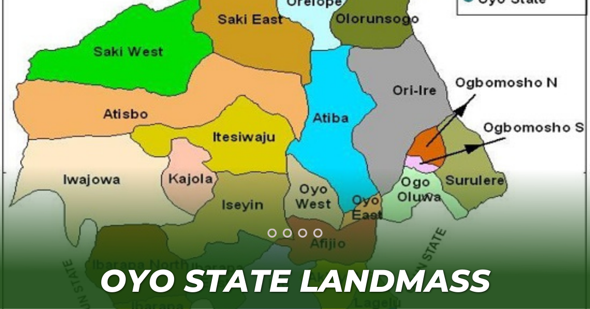
Oyo State Landmass
According to an online report, The Oyo State land mass covers approximately an area of 28,454 square kilometers and is ranked 14th by size. The landscape consists of old hard rocks and dome-shaped hills, which rise gently from about 500 meters in the southern part and reach a height of about 1,200 meters above sea level in the northern part. Some principal rivers such as Ogun, Oba, Oyan, Otin, Ofiki, Sasa, Oni, Erinle, and Osun river originate in this highland.
The indigenes mainly comprise the Oyos, the Oke-Oguns, the Ibadans, and the Ibarapas, all belonging to the Yoruba family and indigenous city in Africa. Ibadan had been the center of administration of the old Western Region since the days of British colonial rule. Other notable cities and towns in Ọyọ State include Ọyọ, Ogbomọsọ, Ibadan, Isẹyín-Okeogun, Ipapo-Okeogun, Kíṣì-Okeogun, Okeho-Okeogun, Saki-Okeogun, Igbeti-Okeogun, Igboho-okeogun, Eruwa-Ibarapa, Iroko, Lanlate, OjeOwode-Okeogun, Sepeteri-Okeogun, Ilora-Oyo, Jobele-Oyo, Awe-Oyo, Ilérò-Okeogun, Okaka-Okeogun, Igbo Ora-Ibarapa, Idere.
Local Government Areas In Oyo State
The Oyo State consists of 33 local governments which are;
- AFIJIO-Jobele
- AKINYELE-Moniya
- ATIBA-Ofa Meta
- ATISBO_Tede-okeogun
- EGBEDA-Egbeda
- IBADAN NORTH-Agodi Gate
- IBADAN NORTH -EAST-Iwo Road
- IBADAN NORTH- WEST-Dugbe/Onireke
- IBADAN SOUTH-EAST-Mapo
- IBADAN SOUTH-WEST-Ring Road
- IBARAPA CENTRAl-Igbo Ora
- IBARAPA EAST-Eruwa
- IBARAPA NORTH -Ayete
- IDO-Ido
- IREPO-Kisi-Okeogun
- ISEYIN-Iseyin-Okeogun
- ITESIWAJU-Oyu-Okeogun
- IWAJOWA-Iwereile-okeogun
- LAGELU-Iyanaofa
- OGBOMOSHO NORTH-Ogbomosho
- OGBOMOSHO SOUTH-Arowomole
- OGO OLUWA-Ajawa
- OLORUNSOGO-Igbeti-Okeogun
- OLUYOLE-Idi Ayunre
- ONA ARA-Akanran
- ORELOPE Igboho-Okeogun
- ORI IRE-Ikoyi
- OYO EAST-Kosobo
- OYO WEST-Ojongbodu
- SAKI EAST-Agoamodu-Okeogun
- SAKI WEST-Shaki-Okeogun
- SURULERE-Iresa Adu
| Names of Local Government | Area (Km²) |
| 1. Afijio | 722 |
| 2. Akinyele | 518 |
| 3. Atiba | 1,757 |
| 4. Atisbo | 2,997 |
| 5. Egbeda | 191 |
| 6. Ibadan North | 27 |
| 7. Ibadan North- East | 18 |
| 8. Ibadan North-West | 26 |
| 9. Ibadan South-East | 17 |
| 10. Ibadan South-West | 40 |
| 11. Ibarapa Central | 440 |
| 12. Ibarapa East | 838 |
| 13. Ibarapa North | 1,218 |
| 14 . Ido | 986 |
| 15. Irepo | 984 |
| 16. Iseyin | 1,348 |
| 17. Itesiwaju | 1,514 |
| 18. Iwajowa | 2,529 |
| 19. Kajola | 609 |
| 20. Lagelu | 338 |
| 21. Ogbomosho North | 185 |
| 22. Ogbomosho South | 68 |
| 23. Ogo Oluwa | 369 |
| 24. Olorunsogo | 1,069 |
| 25. Oluyole | 629 |
| 26. Ona Ara | 290 |
| 27. Orelope | 917 |
| 28. Ori Ire | 2,116 |
| 29. Oyo East | 144 |
| 30. Oyo West | 526 |
| 31. Saki East | 1,569 |
| 32. Saki West | 2,014 |
| 33. Surulere | 23 |
The figures are based on online reports.
READ MORE ON LANDMART.NG


